The Murge
CASTEL DEL MONTE

(Foto di Saliko - Opera Propria)
CC BY 3.0
Castel del Monte is located in Andria, Puglia, along the Adriatic coast of southern Italy, and is situated on high ground overlooking the surrounding region. Built in 1240 by Emperor Frederick II of Swabia, the Castle represents a masterpiece of medieval military architecture, even though it lacks some typical elements such as the moat. Due to its position, the mathematical and astronomical precision of its plan and the perfectly octagonal shape, the Castle reflects the humanistic culture and vast education of its founder: Federico II, in fact, a lover of mathematics, poetry, philosophy and of astronomy, was endowed with a cosmopolitan spirit, so much so that he welcomed Greek, Arab, Italian and Jewish scholars into his court. Thanks to his personality as an enlightened ruler, Frederick II is considered the forerunner of modern humanists and during his reign the intense cultural activity in southern Italy took place in a climate of peace, tolerance and prosperity.
The number eight, which has a highly symbolic value, represents the characterizing element of the castle: eight rooms with a trapezoidal plan develop around the octagonal courtyard, both on the ground floor and on the first floor, forming an octagon, on the corners of which eight towers of similar shape.
Castel del Monte has an outstanding universal value for the perfection of its forms, the harmony and fusion of cultural elements from Northern Europe, the Muslim world and classical antiquity. The castle is built directly on a rocky bank, outcropping in many places. On each of the eight corners, eight towers of the same shape are grafted into the local limestone curtain wall, marked by a string course frame, eight open single-lancet windows on the lower floor, seven mullioned windows and a single three-light window, facing towards Andria, on the upper floor. The courtyard, also octagonal in shape, is characterized by the chromatic contrast deriving from the use of coralline breccia, limestone and marble; once there were also ancient sculptures, of which only the slab depicting the procession of knights and a fragment of an anthropomorphic figure remain. In correspondence with the upper floor there are three French windows, under which there are some projecting elements and some holes, perhaps intended to support a wooden balcony useful for making the rooms independent of each other, all communicating with each other with a circular driveway, for exception of the first and eighth, separated by a wall in which there is a large oculus at the top, probably used for communicating. The sixteen rooms, eight per floor, have a trapezoidal shape and have been covered with an ingenious solution. The space is in fact divided into a central square bay covered with a ribbed cross (with semi-columns in coral breccia on the ground floor and trefoil pillars in marble on the upper one), while the remaining triangular rooms are covered by ogival barrel vaults. The keystones of the cruises are different from each other, decorated with anthropomorphic, zoomorphic and phytomorphic elements. The connection between the two floors takes place via three spiral staircases inserted in as many towers. Some of these towers house cisterns for collecting rainwater, partly also conveyed towards the cistern dug into the rock, below the central courtyard. In other towers, instead, there are the bathrooms, equipped with latrine and sink.
Of great interest is the sculptural equipment which, although greatly impoverished, provides significant evidence of the original decorative apparatus, once also characterized by the wide chromatic range of the materials used: mosaic tesserae, majolica, glass paste and wall paintings, some of which local writers and historians saw traces of it between the end of the 18th century and the beginning of the 19th century, describing them in their works.
Currently there are still two anthropomorphic corbels in the Torre del Falconiere, the telamons that support the umbrella vault of one of the scalar towers and a fragment of the floor mosaic of the eighth room on the ground floor.
How to get there:
By car: 55 km from Bari
GRAVINA DI PUGLIA
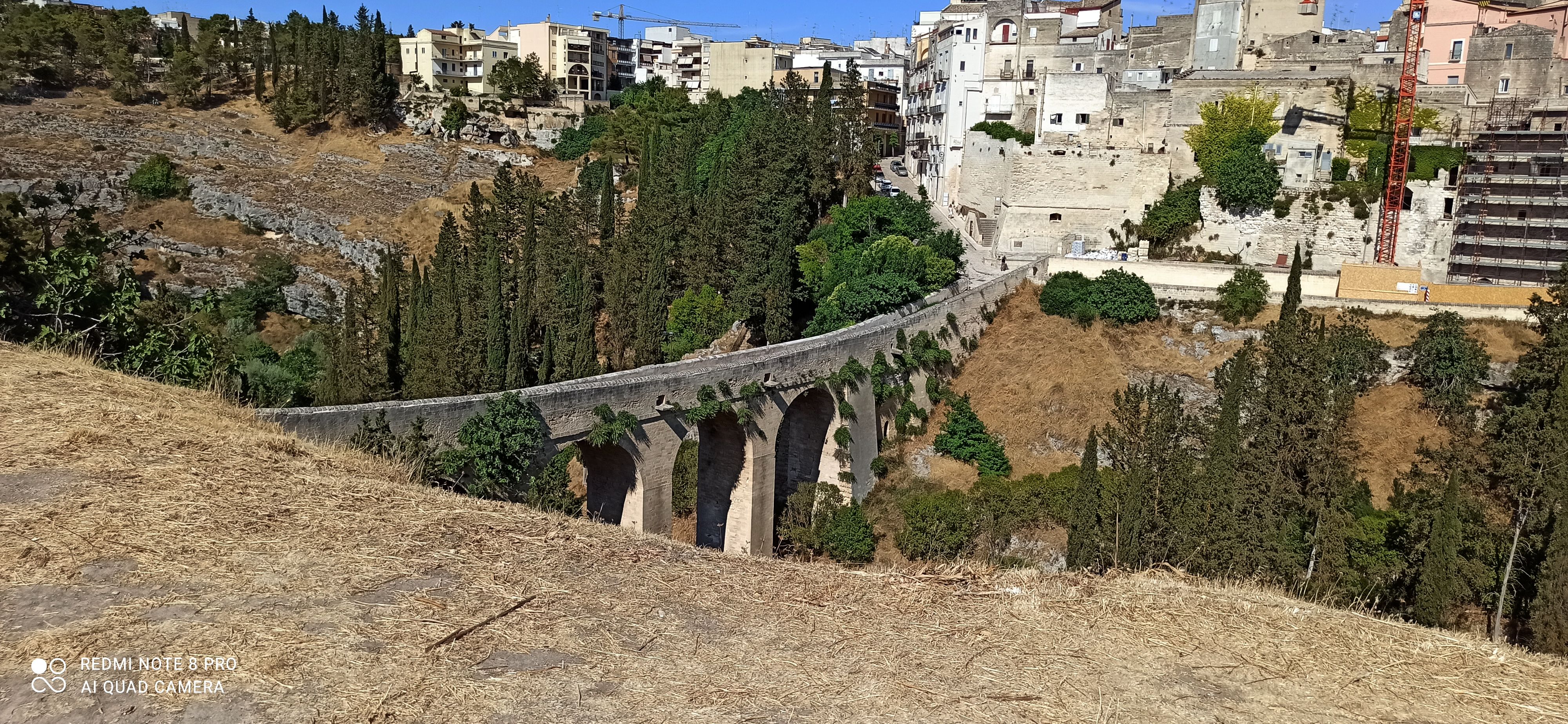
Gravina di Puglia is one of the Apulian localities that preserve artistic and naturalistic treasures of great historical and cultural interest. Its name derives from the Gravina stream which over the millennia has eroded the limestone rock of the plateau giving rise to real canyons which take the name of gorges. Gravina di Puglia has very ancient origins: the current territorial area was inhabited since the Paleolithic, while the findings of the first villages date back to the Neolithic.
It was inhabited for a long time by the Greeks before passing under the control of the Roman Empire, only to be sacked by the barbarians after the fall of Rome. It was an important center throughout the Middle Ages and until the unification of Italy, of which it was the protagonist, giving birth to many revolutionaries and patriots. There are numerous monuments and places of interest, starting from its perfectly preserved medieval historic center and the area of archaeological excavations concentrated above all in the hamlet of Gravina di Botromagno, in which it is possible to perfectly distinguish what was the perimeter of the Neolithic village dating back to 6000 years ago.
The Aqueduct Bridge connects the two banks of the Gravina stream. It is the symbol of the city and of the extraordinary landscape of the Murgia plateau. It was built in the 17th century to be able to cross the Botromagno ravine and reach the rock church of the Madonna della Stella to the west of the city along a 90-metre route at a height of 37 metres. Initially destroyed by the earthquake of 1722, the bridge was rebuilt by the Orsini family with the function of an aqueduct, to convey the waters of the Sant'Angelo and San Giacomo springs under the city walls. As a symbol of the rebirth of the Aqueduct Bridge, the two fountains that still exist today were placed at the ends.
The structure of the bridge was initially made up of 25 arches which were replaced by a tuff back after the serious damage caused by the flood of 1855. The Aqueduct Bridge of Gravina in Puglia hosted in 2019 the filming of "The Last Planet" of director Terrence Malick. In 2020, the spectacular images from the filming of "007: No Time to Die" went around the world.
The historic center of Gravina in Puglia is located close to the ravine and is characterized by an almost circular area formed by 3 districts: Piaggio, Fondovico and Borgo. The alleys of the historic center of Gravina in Puglia host several important historic buildings. In Piazza della Repubblica is the Palazzo Ducale, home of the Orsini family who ruled the city for five centuries.
Piazza Benedetto XII houses the Bishop's Palace, built in the 9th but rebuilt in the 16th following the collapse caused by the earthquake of 1456. Piazza Notar Domenico houses the Biblioteca Capitolare Finya, one of the oldest libraries in Puglia which houses a collection of over 11,000 volumes.
As for religious architecture, the most important church in the city is the cathedral of Santa Maria Assunta, built in 1092 but rebuilt in the 15th century following a devastating earthquake. The church is located overhanging the ravine, thus offering a truly suggestive glimpse, and is surrounded by a green lawn that contrasts with the surrounding barren landscape. Inside there is an imposing perfectly functioning pipe organ built in the early twentieth century. Then there are the churches of San Sebastiano, the church of Santa Maria del Suffragio (known as the church of Purgatory) and the church of San Francesco.
Among the civil architectures, particularly noteworthy is the Federiciano Castle, dating back to 1231 and built by Frederick II of Swabia. The castle, now in ruins, had a rectangular plan with four towers and was spread over three floors. Below the city there is also a dense system of cisterns, tunnels and tunnels known as Gravina Sotterranea, which came to light only in recent years and is still being studied.
Of great tourist interest is Gravina Sotterranea, an underground network obtained from excavations for the extraction of tuff. By digging the ground to obtain material with which to build the houses and palaces of the city, over the centuries the inhabitants of Gravina have created enormous underground rooms under the buildings themselves, often used as cellars.
How to get there:
By car: 60 km from Bari
By train: 1h 30’ (Ferrovie Appulo Lucane)
MATERA
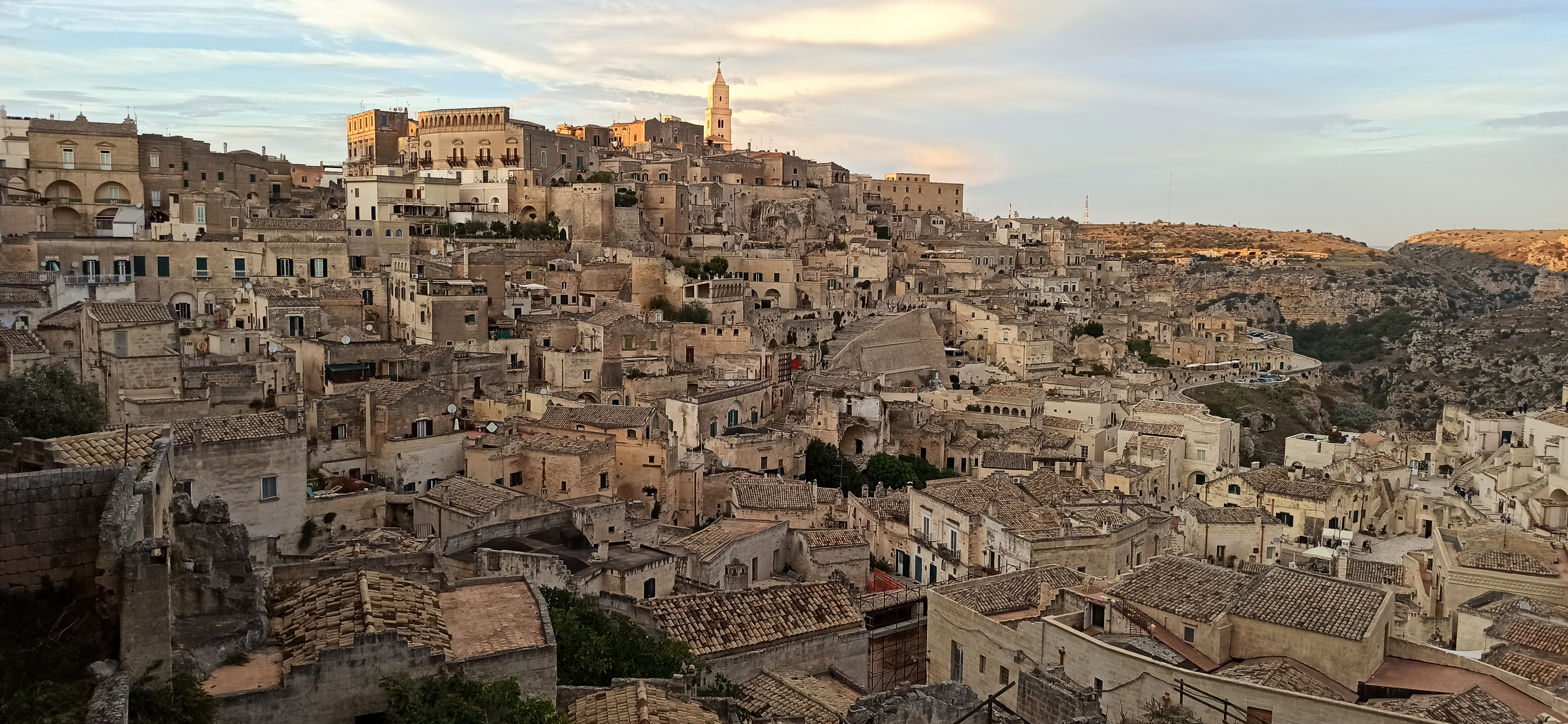
Matera is one of the oldest cities in the world whose territory preserves evidence of human settlements starting from the Paleolithic and without interruption up to the present day. It represents an extraordinary page written by man over the millennia of this very long history. Matera is the city of the Sassi, the original urban nucleus, which developed starting from the natural caves dug into the rock and subsequently modeled into increasingly complex structures within two large natural amphitheatres which are the Sasso Caveoso and the Sasso Barisano.
The unrepeatable architecture of the Sassi of Matera tells of man's ability to adapt perfectly to the environment and the natural context, masterfully using simple characteristics such as the constant temperature of the excavated rooms, the calcarenite itself of the rocky bank for the construction of the houses external territory and the use of the slopes for the control of water and meteoric phenomena. The architectural structure is made up of two systems, the immediately visible one created with the successive stratifications of houses, courtyards, galleries, palaces, churches, roads, vegetable gardens and gardens, and the internal and invisible at first sight consisting of cisterns, neviere, caves, tunnels and water control systems, essential systems for the life and wealth of the community.
Originally the Sassi of Matera were a rock environment very similar to the one in which the park in front is located on the other side of the canyon excavated by the Gravina di Matera. The side of the Sassi, the western one, is characterized below by steep walls that overlook the stream. Above, the slope presents a series of terraces, hills and plains more suitable for human settlement, places which over the millennia have been transformed from rocky villages into a real city.
Particularly interesting are the Rupestrian Churches that can be visited in the Sassi of Matera. These places bear witness to the evolutionary passage of man from the prehistoric phases to Christianity. The Rupestrian Churches are in fact found in places of particular importance and in all probability they were already places of worship in the rock civilizations that preceded the Christian one.
The historic center of Matera is located on a plateau which borders the Sassi of Matera at the top. Here too Matera shows different levels of overlapping of urban layers. In fact, in the central square Piazza Vittorio Veneto there are openings that show the original level of the places, today called hypogea, which are located below the same square. The hypogea are articulated in continuity forming a real submerged city connected with the Sassi. Here there are exceptional rock structures such as the large cistern called Palombaro Lungo with walls 15 meters high and until recently navigable.
The historic center of Matera develops with streets that connect different squares along an axis called the eighteenth-century axis of the city because it took on its appearance starting from the end of the 1600s. In the center of Matera there are a series of important palaces and churches that have had a particular importance throughout the history of the city.
Piazza Vittorio Veneto is dominated by the large Palazzo dell'Annunziata, a former convent which now houses the Provincial Library. Opposite the large building of the Prefecture, the thirteenth-century Church of San Domenico, the Church of the Knights of Malta. In the center of the square there are four large openings showing the hypogea where there is also the large cistern of Palombaro Lungo, and the rock church of S. Spirito dating back to the 10th century AD. A little further on is another former convent, that of S. Lucia alla Fontana which divides the eighteenth-century church of the same name on the right and the Ferdinandea fountain on the left. Continuing along via del Corso you reach piazza San Francesco d'Assisi where the imposing seventeenth-century church of the same name is located. Here too there are hypogea which bear witness to the original level of the places below the square. To the right of the square, take via Ridola, dedicated to Domenico Ridola for his studies and research into the city's archaeological past. On the left instead is Piazza del Sedile, seat of the Conservatory, formerly Palazzo di Città and seat of the Municipality of Matera, from here all the most important noble palaces follow one another which from the square through the narrow via Duomo come to surround the Cathedral of Matera.
From Piazza del Sedile going up via Duomo you arrive at the Cathedral dating back to 1270 flanked by a majestic bell tower which dominates the entire panorama of the city. The Cathedral has an Apulian-Romanesque style, but is characterized by unique artistic details and elements of great value both inside and out. Around the Cathedral rise the palaces of families with noble titles who lived there such as Palazzo Gattini (Conti Gattini), Palazzo Venusio (Marquis of Venusio), Palazzo Malvinni Malvezzi (Duchi Malvinni Malvezzi). In addition to the palaces, these families also had vast estates in the territories of the Murgia and the Matera countryside. These palaces were erected for the purpose of constituting defense principals of the mother church. Continuing to the right from Piazza S. Francesco you enter Via Ridola where the Church of Purgatorio is immediately found. On the right side is the Domenico Ridola National Museum where most of the finds from the archaeological research conducted by Domenico Ridola in the Matera area are exhibited.
At the end of via Ridola is Piazzetta Pascoli bordered by another large building, Palazzo Lanfranchi, now home to the National Museum of Medieval and Modern Art of Basilicata. On the left a belvedere overlooking the Sasso Caveoso, a very beautiful panorama dominated in the center by the rocky spur of Monterrone.
How to get there:
By car: 65 km from Bari
By train: 1h 50’ (Ferrovie Appulo Lucane)